Garmin Colombia
Showing all 4 results
-
High Digital Range
Garmin eTrex® 20x 2,2” 4 GB, compatible con HotFix® y GLONASS
010-01508-00 Garmin eTrex® 20x 2,2” 4 GB, Compatible with Hotfix® and Glonass Buy your Distributor in High Digital Store, technology supplier and wholesaler in Colombia at the best price on the market. Offers products from the manufacturer Garmin.

Visualize the way
ETREX 20X has an improved screen of 2,2 inches and 65.000 colors that can be read in sunlight. Durable and water resistant, The Etrex 20X unit is designed to withstand weather inclement. Presents an improved interface, But it retains its resistance to face dust, dirt, moisture or water.
Go anywhere
Place your Etrex 20X practically anywhere thanks to its wide range of compatible supports. Use the automobile assembly function and the City Navigator NT® maps to receive driving instructions turn to turn or a much more resistant support to use it on a bicycle or quad. You can even ride it on a boat for your fishing trips or to navigate.
Be global
The Etrex series can track GPS and Glaness satellites simultaneously: has the ability to set the position with 24 Satellites more than using only GPS. It's more, The time it takes to set the position is (on average) and 20 % faster than using only GPS. With GPS receiver with high sensitivity egnos and Hotfix satellite prediction, The Etrex unit locates your position quickly and accurately, and maintains the location GPS even in thick forests and in high depth valleys.
Discover the fun
ETREX 20X admits GPX GPX files GPX files for endless geocaching adventures. Visitageocaching.com to download geocachés directly on your device and start looking for caches. ETREX 20X stores all key information, including location, The terrain, The difficulty, tips and descriptions. Not using paper, Not only are you helping the environment, but also avoid discomfort of having to introduce coordinates manually.
Plan your next trip
Take control of your next adventure with Basecamp™. Free travel planning software allows you to see and organize maps, Routes and much more, and even create Garmin adventures to share with friends, Family members or companions explorers. Basecamp shows 2D or 3D topographic maps data on the computer screen, as well as a wide range of satellite images when linked to a subscription to Birdseye satellite images.
Main features
Garmin étrex® 20x screen with sharp colors 2,2 inch. Hotfix® and Glonass compatible high sensitivity GPS receiver. 4 Internal memory GB. Can be expanded with a microSD card™ (not included). World base map with shaded relief.
Brand:Garmin ColombiaMemory:4GBscreen:2,2″Reference:Etrex® 20xSKU:010-01508-00Dic 9, 2019, 06:18 PMSKU: n/a -
High Digital Range
Garmin GPSMAP 64x, 2,6″ quadrifilar helical antenna, three-axis compass with barometric altimeter
 High Digital Range
Garmin GPSMAP 64x, 2,6″ quadrifilar helical antenna, three-axis compass with barometric altimeter
010-02258-01 Garmin GPSMAP 64x, 2,6″ quadrifilar helical antenna, brújula de tres ejes con altímetro barométrico Compra en Tienda Alta Gama Digital tu distribuidor, technology supplier and wholesaler in Colombia at the best price on the market. Offers products from the manufacturer Garmin.

Explora el mundo con una navegación fiable a mano
Navega por tu siguiente aventura con los navegadores de mano de la serie GPSMAP 64x. Tanto si practicas senderismo, ciclismo, geocaching o escalada, podrás explorar más con la mejor navegación de Garmin en la palma de tu mano. Besides, los navegadores de esta serie ofrecen compatibilidad con varios sistemas GNSS.
Seguridad ante todo
Gracias a su antena cuadrifilar helicoidal, su receptor de alta sensibilidad y la compatibilidad con varios sistemas de navegación global (GPS, GLONASS y Galileo), los navegadores de la serie GPSMAP 64x obtienen tu ubicación con rapidez y precisión, y la mantienen en entornos más exigentes que si solo se utiliza el GPS.
Añade mapas
Con una memoria interna de 8 GB y una ranura para tarjeta microSD™ que permite ampliar el almacenamiento, puedes descargar con comodidad incluso más mapas.
Imágenes por satélite
La serie GPSMAP 64x también es compatible con Imágenes por satélite BirdsEye (requiere suscripción), de forma que podrás cargar imágenes por satélite e integrarlas en tus mapas.
Discover the fun
La serie GPSMAP 64x cuenta con funciones de geocaching sin papeles. Carga archivos GPX directamente en el dispositivo y visualiza información clave como la ubicación, el terreno y consejos de Geocaching.com.
Main features
Garmin GPSMAP 64x, Diseño robusto y resistente al agua con funcionamiento mediante botones y una pantalla en color de 2,6″ que se puede leer con la luz del sol, Conoce siempre tu ubicación con un receptor de alta sensibilidad con antena cuadrifilar helicoidal y compatibilidad con varios sistemas GNSS (GPS, GLONASS y Galileo); los modelos GPSMAP 64sx ofrecen una brújula de tres ejes con altímetro barométrico, Los modelos GPSMAP 64sx ofrecen conectividad inalámbrica mediante las tecnologías Bluetooth® y ANT+®, Autonomía de la pila/batería: until 16 horas en modo GPS.
Brand:Garmin Colombiascreen:2.6″Operating system:Pc, Mac and More Mobile Devices.Reference:MAP 64XSKU:010-02258-01Dic 10, 2019, 02:54 PMSKU: n/a -
High Digital Range
Garmin GPSMAP® 64sc Camera 8 megapixels, Compass of 3 axes with Bluetooth ® or ANT barometric altimeter
 High Digital Range
Garmin GPSMAP® 64sc Camera 8 megapixels, Compass of 3 axes with Bluetooth ® or ANT barometric altimeter
010-01199-30 Garmin GPSMAP® 64sc Camera 8 megapixels, Compass of 3 axes with barometric altimeter Bluetooth ® or ANT Buy at Tienda Alta Gama Digital your distributor, technology supplier and wholesaler in Colombia at the best price on the market. Offers products from the manufacturer Garmin.

Explore the terrain
GPSMAP 64s comes with an integrated worldwide basemap with shaded relief plus a BirdsEye satellite imagery subscription from 1 year, so you can navigate anywhere with ease. With photo navigation, You can download geotagged images from the Internet and navigate to them.
Document your trip
Capture the highlights of your outings on the autofocus camera. 8 megapixels. Each photo will automatically be geotagged with the location of where it was taken, allowing him – or the people you share your photos with – easily navigate back to that location in the future.
Orient
GPSMAP 64sc has an electronic compass 3 tilt compensated axles, that shows your heading even when stopped, without keeping it level. Your barometric altimeter tracks pressure changes to pinpoint your exact altitude, and you can even use it to plot barometric pressure over time, which will help you keep an eye on changing weather conditions.
Wireless sharing
Comparte tus waypoints, clues, routes and geocaches wirelessly with other compatible devices. Your friends can enjoy your favorite walk or cache without waiting for you to connect to your computer – just press “to send” to transfer your information to another Garmin handheld.
GPSMAP 64sc also connects to compatible Garmin devices, including VIRB® action cameras, as well as accessory sensors, including tempe ™ and heart rate monitor.
stay connected
With Smart Notification you can receive email, texts and alerts wirelessly from your compatible smartphone. Stay connected without having to dig in your backpack for your smartphone.
Save your arrangement
With its four-propeller antenna and high-sensitivity GPS and GLONASS receiver, GPSMAP 64sc locates your position quickly and accurately and maintains your location, even in heavy cover and deep canyons. The advantage is clear: either in deep forests or near tall buildings and trees, You can count on GPSMAP 64sc to help you find your way when you need it most.
Find Fun
GPSMAP 64sc supports paperless geocaching with 250.000 caches preloaded with hints and descriptions from Geocaching.com, and has a battery 16 Hours of duration. By going paperless, You are not only helping the environment, but also improving efficiency. GPSMAP 64sc stores and displays key information, including location, ground, difficulty, tips and descriptions, which means no more manual coordinates and paper printouts. Thin and light, 64sc is the perfect companion for all your outdoor activities.
Main features
Garmin GPSMAP® 64sc Autofocus Camera 8 megapixels with automatic geo-tag, High sensitivity GPS and GLONASS receiver with quad helix antenna, Subscription to 1 year of BirdsEye Satellite Imagery, Compass of 3 axles with barometric altimeter, Wireless connectivity using Bluetooth ® or ANT technology.
Camera:8 megapixelsBrand:Garmin Colombiascreen:2.6″Operating system:Pc, Mac and More Mobile Devices.Reference:MAP 64scSKU:010-01199-30Dic 10, 2019, 10:26 AMSKU: n/a -
High Digital Range
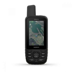
Garmin GPSMAP® 66s 3″ the flashlights are LED, three axis compass, barometric altimeter
 High Digital Range
Garmin GPSMAP® 66s 3″ the flashlights are LED, three axis compass, barometric altimeter
010-01918-00 Garmin GPSMAP® 66s 3″ the flashlights are LED, brújula de tres ejes altímetro barométrico Compra en Tienda Alta Gama Digital tu distribuidor, technology supplier and wholesaler in Colombia at the best price on the market. Offers products from the manufacturer Garmin.

Oriéntate
Además de servicio multisatélite, la serie GPSMAP 66 también dispone de sensores de altímetro, barómetro y brújula (ABC) para facilitar el seguimiento de tu ruta. El altímetro incorporado ofrece datos de altitud para controlar de manera precisa los ascensos y descensos, mientras que el barómetro puede utilizarse para predecir los cambios meteorológicos, ya que muestra los cambios a corto plazo que se producen en la presión del aire. La brújula electrónica de tres ejes mantiene tu rumbo tanto cuando te estás desplazando como cuando no.
Main features
Garmin GPSMAP® 66s Amplia pantalla en color de 3″ legible a la luz del sol para una visualización cómoda. Soporte de varios sistemas globales de navegación por satélite (GNSS) para hacer un seguimiento de tus rutas en entornos más exigentes que si solo se utiliza el GPS, más brújula de tres ejes y altímetro barométrico. Acceso a Imágenes por satélite BirdsEye con descargas directas al dispositivo y sin suscripción anual. La conectividad inalámbrica ampliada permite utilizar Active Weather para contar con previsiones actualizadas y un radar meteorológico animado, y la función Geocaching Live ofrece sincronización con un teléfono móvil y la posibilidad de recibir actualizaciones. Compatible con la página web y la aplicación Garmin Explore™, para que puedas gestionar tus tracks, rutas y waypoints, y revisar las estadísticas durante tus actividades al aire libre. Función de linterna LED y hasta 16 horas de autonomía de la batería en el modo GPS y 1 semana en el modo bajo consumo para reducir las recargas.
Brand:Garmin Colombiascreen:3″Operating system:Pc, Mac and More Mobile Devices.Reference:MAP® 66sSKU:010-01918-00Dic 9, 2019, 05:38 PMSKU: n/a


